|
|
Loading...
| ||
|
Loading... |
| If you Auto Search (press ENTER) now... | [Press ESC to close &, down-arrow to open, TAB to autocomplete] |
| Fly To Geocode Result |
| Filter Breakdown |
| Session View Filter History |
| Search Suggestions |
Note: even though site icons may differ from the selected carrier, those sites host co-located networks and will have assignments belonging to the chosen carrier - click on the site marker to find out. Also, results do not include network roaming. Enter a complete or partial callsign to show. You may use the * and ? wildcard characters to find matching HAMs and change the map's bounds to show them all. | ||||
|
Map bounds:
|
||
A view filter comprised of multiple conditions can be built here. A search is NOT performed automatically after the filter is modified or cleared - you must click one of the 'action' buttons at the bottom of this dialog.
|
|
| Site description: | |
| Client name: | |
| Frequency | |
| Range | |
| Emission designator: | |
| Callsign: | |
This web app shows you where all of Australia's registered radiofrequency transmitters are found ![]() .
.
Cell towers are specifically indicated by the carrier's icon, or a red mobile phone ![]() .
.
You can:
For more information regarding searching (e.g. how to specify certain parameters), see 'Help'.
|
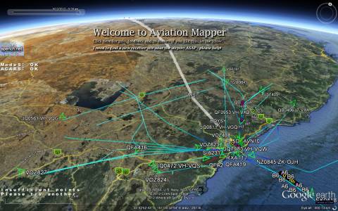
Aviation Mapper is live! Click here to try it. AvMap is a real-time web-streaming 3D visualisation of Sydney airspace in your browser using Google Earth. |
The brand-spanking-new tile image layer system is finally here and ready for public beta testing.
A few of the layers should have automatically been switched on for you: "Black" to darken the map, elevation data from NASA's Shuttle Radar Topographic Mission, all registered sites, and all point-to-point links.
To avoid automatically fetching sites when exploring the tile layers at different zoom levels, make sure you un-check the "Fetch sites" check box in the top-right of the map.
If you don't see anything, zoom out. Please tell me what you think!
INTERNET EXPLORER USERS: Everything works now, however IE's tile image compositing is very slow and the quality is terrible. Please switch to Firefox, Chrome, Safari or Opera - they are all snappy, standards-compliant and produce beautiful results!
For the ~10% of you, Internet Explorer 7 and below will no longer be supported. Although everything will still work, it is slow and does not render various UI elements correctly.
If you use it, please switch to something far better like Chrome or Firefox, which offer standards-compliance and optimal performance for this site.
If you have a moment, please let me know what you think of the Wizard and View filter (Feedback button on the top right of the map). Thank you!
RFMap by Balint Seeber, 2010-2011.
All tile image content is © copyright. Screenshots accompanied with a link back here are permitted.
This site makes use of:
Important legal notice:
The following Telstra, Optus, Vodafone and Hutchison '3' logos:
![]()
![]()
![]()
![]()
are trademarks, belong to their respective owners, and are used on this site under fair use for the purpose of non-commercial research. Absolutely no sponsorship is suggested by their use, and none of the aforementioned companies is in any way affiliated with this site. The logos are used solely to demarcate transmitter sites (which is already publically accessible through the ACMA RadCom database) and nothing further.
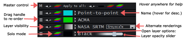
The following shows the various parts of the tile control interface in the bottom-left corner of your browser window:
Here are some tips for efficient searching using the search text field above the map:
If you wish to precisely set filter fields, enter one of the following letters and a space before the term(s):
Following such a letter, terms can be grouped using double quotes - if not, only the next word is used. To specify a phrase inside such double quotes, use a single quote (e.g. s "'some site'").
If you wish to move the map and set a filter, enter the location, followed by a full stop (.), then the filter expression (as above).
Pressing ENTER (equivalent to clicking Auto Search) will try to determine whether you want to fly somewhere, or filter site results. If the opposite action (to what you wanted) occurs, click the hyperlink in the orange box that briefly appears.
For manual control, click Fly To to move the map to that location, or click Filter to filter currently visible sites.
If you want to search for words in a site description or client name, simply type them in. If you want to search for an exact phrase, enclose the phrase in double quotes (e.g. "some thing").
If multiple criteria are required, separate the appropriate terms by commas. For example: telstra, optus, voda, hutch. Not using commas would look for sites and clients containing all those words.
You can filter by frequency by entering in a number, optionally followed by a unit (khz, mhz, ghz). If you want to search a range add a:
Fully-formed emission designators are also automatically detected. You can specify a wildcard search using ? (one character) and * (zero to many characters).
Valid, fully-formed Australian callsigns are automatically detected (wildcard searching is now available).
IMPORTANT ANNOUNCEMENT - PLEASE READ
Dear visitor,
Thank you for using this web app – it has seen a steady increase in traffic since its launch two years ago, and I appreciate you spending your time here.
Despite this, I am unable to continue running the site as a free service.
If you find this service valuable please contact me.
I hope you can appreciate my position.
Yours sincerely,
Balint Seeber
Please click the 'Close' button to continue.